Thursday, August 2, 2012

Fish ladder will give herring a leg up in Marstons Mills

River herring swim past a sign marking where a cross section of the flume and banks will be surveyed.  Next year they will swim through a brand new fishway on their way to the spawning grounds at Middle Pond.

By Lindsay Cook, CCCD Intern and Abigail Franklin, CCCD Fish Passage Project Manager
The Cape Cod Conservation District is constantly on the lookout for areas where the staff’s hard work would help to protect or restore habitats for Cape Cod’s diverse wildlife and fish species. One of the areas that will soon benefit from the Cape Cod Water Resources Restoration Project is in the Marstons Mills section of Barnstable, Massachusetts.
In April, a crew from the CCCD, USDA Natural Resources Conservation Service and the Town of Barnstable went to the site of a 1,200 foot long wooden flume and fish ladder along the Martsons Mills River that provides river herring a way to swim around some cranberry bogs on their way to the spawning grounds in Middle Pond. 
Rick DeVergilio (left), Project Coordinator with the Cape Cod Conservation District and Dan Barnett, NRCS Project Engineer measure the slope of the fish flume banks and discuss methods for stabilizing them during construction.
The existing structure, first built in the 1880’s and rebuilt in the 1940’s and 1990’s, has always required constant maintenance by local volunteers and town employees.  Today, many sections are rotting, causing water to leak out the sides. The weirs – or ladder steps – are prone to clogging by debris, and the difference in water levels in the concrete water control structure tends to delay the migrating fish.
To correct these problems, the fish ladder and flume will be replaced with a watertight concrete structure that will allow for more efficient use of water from the pond.  A path along the structure will help volunteers remove sticks and leaves from the weirs, and two new steps will be added in the water control structure to help fish swim through.
The design for the project is 85 percent complete and several meetings have been held with the project partners, including the residents who live along the ladder. The projected life of this new ladder is much longer than the wooden structures of the past and will therefore not need to be rebuilt again and again.
During the April site visit, the crew surveyed the banks on either side of the flume to determine how to preserve as many trees as possible during the construction process.  Maintaining tree cover is important to keep the water cool for the passing herring. 
Alisha Parker, Property Management Coordinator with the Town of Barnstable  Growth  Management Department carries stakes to the next cross section that will be surveyed.
Stakes were placed every 100 feet, the slope of the banks was surveyed, tree locations were recorded, and pictures were taken. Thanks to the help of the project partners, the work was accomplished in an afternoon. 
At the end of the day, some herring swam by to take a look at the progress! Take a look:

Wednesday, June 13, 2012

Protecting shellfish at Wychmere Harbor, Harwich

Construction crews install a stormwater treatment system near Wychmere Harbor, Harwich.

by Lindsay Cook, Conservation Intern, Cape Cod Conservation District

The Cape Cod Water Resources Restoration Project recently completed another step in improving the water quality of our local shellfish beds. Before October 2011, there was a troubling situation at Wychmere Harbor in Harwich. Stormwater was flowing over 21,000 square feet of impermeable surface, picking up debris and environmental contaminants, before draining, untreated, into the harbor.

The town was concerned about this situation because Wychmere Harbor supports a valuable population of quahogs and is one of the few places Harwich residents can shellfish. To correct the situation, 55 flow diffusers, seven catch basins, and two leaching chambers were installed to catch and treat runoff coming from the Wychmere Harbor parking lot and the adjoining section of Harbor Road. 

“That's nice,” you might be saying to yourself... “But what does that all mean?”

First and foremost, it means that 14 acres of shellfish beds will benefit from the filtering of stormwater that previously ran untreated into the bay. During the treatment process, contaminants found in stormwater, such as fertilizers, metals, and fecal coliform bacteria are removed from the water, as well as the majority of its suspended solids.

This is good news for shellfishers because in order for shellfish beds to be harvested, the waters overlying the beds must meet rigorous water quality standards. To determine the water quality overlying the shellfish beds, researchers collect water samples and test for the presence of fecal coliform bacteria. In areas where there are high levels of fecal coliforms the shellfish beds are shut down.

Thanks to the stormwater treatment at Wychmere Harbor, local shellfishers should be able to harvest these valuable shellfish populations for years to come. 

Friday, April 27, 2012

Restoring salt marshes at Red River Beach in Harwich

Making room for the new culvert under Deep Hole Road

by Lindsay Cook, Cape Cod Conservation District intern

If you've been to Red River Beach in Harwich lately you might have noticed that construction is underway. So often, the sound of construction equipment means bad news for the environment, but not this time! This construction was planned as a part of the Cape Cod Water Resources Restoration Project (CCWRRP) and, when completed, will help restore and protect the native salt marsh communities behind Red River Beach.

Historically, there were three healthy salt marshes behind Red River Beach: the upper marsh, middle marsh, and lower marsh. As the tide came in, it moved up Red River and pushed tidal waters down a tributary to feed the marshes. However, when Uncle Venies Road and Deep Hole Road were extended to provide access to the beach, tidal waters were restricted.

A culvert was put under each road to allow tidal flow to enter both the middle and upper marsh, but they were too small. At 24 inches in diameter, only limited tidal waters made it to the middle marsh and even less made it to the upper marsh. Salt marshes like these that do not receive a natural amount of tidal water are termed “tidally restricted.”

Map of the site showing the three marsh areas
After years of being tidally restricted, the upper and middle marshes began to show clear signs of stress, including the establishment of invasive species such as common reed (a.k.a. Phragmites australis) and poor water quality.

Tidal flow restricted by undersized culvert
With funding from the CCWRRP, the Town of Harwich will restore the marshes to their former healthy state.

To do this, the Town will replace the undersized culverts with much larger box culverts (4ft x 8ft under Uncle Venies Road and 3ft x 4ft under Deep Hole Road) that will allow adequate tidal flow to come in to both marshes and, in time, restore the natural salt marsh habitat and improve water quality.

The mouth of Red River

This video below discusses the salt marsh restoration project at Red River Beach in more detail:


Red River Marsh Restoration by Tom Leach

Friday, March 9, 2012

Stormwater technology in action in Mashpee


Plastic treatment chambers in a modified stormwater system.
By Lindsay Cook, Cape Cod Conservation District intern

Until the Fall of 2011, stormwater ran untreated into Popponesset Bay and Nantucket Sound. That’s when seven stormwater systems were installed underneath Mashpee Neck Road in the Mashpee. Stormwater is now filtered, removing contaminants before it enters the bay. These improvements will protect 102 acres of shellfish beds!

There are many factors to consider when installing a stormwater system. First is the amount of water to be treated. These systems are designed to handle the first inch of rainfall; researchers have found that 85 percent of all contaminants are absorbed and transported in the first inch of rain.

Second is the depth to the high water table. In order for stormwater systems to be safe for drinking water, the bottom of the system must be located at least two feet above the high water table. At the Mashpee Neck Road site, the first two sites easily cleared this threshold, but sites three through seven did not. Therefore, the first two sites received a conventional system and the others received a modified system that took up less vertical space than a standard system.

The conventional systems use leaching chambers and catch basins. When stormwater rushes down Mashpee Neck Road, it enters a catch basin through a manhole. A catch basin is a large concrete holding tank where water accumulates and particulate matter settles out. Particulate matter is anything from sand and leaves to gum wrappers and popsicle sticks.

After the particulates have settled to the bottom, the clearer water on top moves into a plastic pipe which leads to a leaching chamber. The leaching chamber has many small holes in the sides that let water out slowly. As the water fills up from the bottom, it trickles out the holes into an area of sand and rock where contaminants are filtered out.

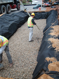
Laying down washed gravel for contaminant filtration.

The modified systems use small plastic treatment chambers instead of the larger leaching chambers of the conventional system. Because of their smaller size, the chambers must be placed side by side over a much greater area to absorb the same level of stormwater runoff than a conventional system could. More than 1,000 of these treatment chambers were installed underneath the road!

In April more work will be done at this site. Stay tuned for details about the artificial wetland that will be built in the final phase of this project.

Tuesday, January 31, 2012

Water gets cleaner beneath your feet at Duck Creek, Wellfleet


Wes Stinson (left) of Environmental Partners Group and Lee Davis, Chair of the Cape Cod Conservation District, hold a floating debris trap that will be installed beneath the street. The trap will catch oil and large debris before they reach sand and fabric filters, also under the street.


By Abigail Franklin, Cape Cod Conservation District and Chloe Wardropper, NRCS conservation intern

One of the most photographed sites on Cape Cod is Uncle Tim’s bridge in Wellfleet. Few people know however that the water quality under this bridge has been affected by the nearby roads and parking lots.  Like many asphalt roads and parking lots near open water, Commercial Street and Holbrook Avenue have been channeling untreated surface water – stormwater – into Duck Creek because of their large impervious surface areas. Stormwater usually carries contaminants such as fertilizer and bacteria that flow directly into surface water if not first caught and filtered.

Fortunately a stormwater treatment project is in progress that will significantly improve the water quality of Duck Creek. Traffic is being affected along Commercial Street between Bank Street and Holbrook Avenue, but the disturbance is only temporary. Soon, cleaner water will be filtering into the saltmarsh thanks to the installation of 12 separate underground containment and purification centers.

Construction crews have been removing pavement in sections and digging holes for catchment and treatment basins since November 2011.  The catchment basins collect untreated stormwater runoff. From there, water flows into connected leach basins where it trickles slowly downward through porous material that removes pollutants. 

Oddly shaped green plastic devices called floating debris traps will be positioned over the discharge pipes leading from the catchment basins into the infiltration systems. Their job is to collect oil and large debris that can impair the function of the sand and filter fabric that treats the contaminated water. The oil, debris and other sediment will be removed when the Town empties the catch basins twice a year.


Duck Creek is a central feature in Wellfleet’s historic downtown, and the stormwater treatment is important to restore water quality, improve wildlife habitat, and to potentially allow shellfish growing and harvesting in the future.  So they next time you walk past a storm grate, think of all the good work that’s being done underneath your feet!


Watch the Duck Creek stormwater project evolve in this video slideshow:

Monday, January 9, 2012

Water quality makeovers in Brewster: Paine’s Creek Landing and Saint’s Landing Beach stormwater projects

Stormwater improvements under construction at Paines Creek Landing, Brewster
By Chloe Wardropper, USDA-NRCS Conservation Intern and Abigail Franklin, Cape Cod Conservation District

Cape Cod’s Town of Brewster recently received a water quality makeover at two important shellfishing and recreation areas.  Until recently, Paine’s Creek Landing and Saints Landing Beach, five minutes apart on Cape Cod Bay, had an unfortunate commonality: they discharged stormwater into the Bay.  Like many asphalt roads and parking lots near open water, the paved surfaces at Paine’s Creek and Saint’s Landing were channeling untreated surface water – stormwater – into an important water body because of their large impervious surface areas. So the Cape Cod Water Resources Restoration Project installed underground systems to catch and treat this stormwater to prevent more harmful contaminants from entering Cape Cod Bay.

What are impervious surfaces?  A surface – such as an asphalt road – is impervious when water cannot seep through it.  A sponge, for instance, is a pervious surface, while a dinner plate is impervious.  When water encounters an impervious surface, it runs downhill until it hits a surface it can sink into.  As it flows, water picks up contaminants such as fertilizer and bacteria.  Wetlands serve as natural water catchments and play the crucial role of filtering out contaminants in water before it seeps back into the groundwater. 

There are many places in developed areas, however, where there are insufficient wetland and other pervious surface areas to absorb periodic high flows of stormwater running off paved roads.  These areas benefit greatly from stormwater runoff treatment systems. 

The treatment systems installed at Paine’s Creek and Saint’s Landing in Brewster are called infiltration systems.  Like the Barley Neck Road project in Orleans, they consist of catchment basins connected to leaching basins.  The catchment basins are placed underground at the bottom of an impervious slope and collect the untreated stormwater runoff.  Water then flows into the leach basins where it trickles slowly downward through porous material that removes pollutants.

At Saint’s Landing, two separate catchments direct water into leach basins installed under the beach parking lot.  And at Paine’s Creek, the Town of Brewster decided that in addition to leach systems they would go one step further in protecting Cape Cod Bay water quality by moving the entire parking lot farther inland.  The new location also addresses beach erosion issues and creates more beach area for residents and visitors. 

Watch video slideshows of the work progressing at these project sites:

A Water Quality Makeover at Paines Creek Landing, Brewster


A Water Quality Makeover at Saints Landing Beach